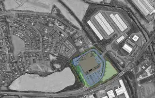
Development Land, Carnbane Way, Newry, BT35 6PQ
Price Not Provided
Contact Savills (NI) Ltd

Description & Features
- Site extending to about 8.3 acres (3.36 ha)
- Zoned Local Landscape Policy Area in the Banbridge/Newry & Mourne Area Plan 2015
- Full planning permission for foodstore extending to 8,650 sq. m with carparking
- Well located site immediately adjacent to Carnbane Industrial Estate
- Strong connectivity with direct access onto A28 and A1
- Potential to increase the number of units on site (STP)
The subject property comprises prime development lands extending to a total site area of 8.3 acres (3.36 ha). The site is located within the development limit of Newry and is zoned as a Local Landscape Policy Area in the Banbridge/Newry & Mourne Area Plan 2015 (Ref: NY 114).
The site is rectangular in shape and the topography is gently undulating, ranging in elevation from about 11meters above sea level to the north, to about 30 meters above sea level to the south. The site benefits from excellent road frontage and is currently accessed off the A28 at the north of the site, with provision for further access onto the Carnbane roundabout. It is bounded by the Newry river to the west, settled housing to the south, and a proposed residential development site to the east.
The site is part of a larger development scheme and benefits from full planning permission for 1 No. foodstore and associated car parking under planning reference P/2009/0163/F. Please note that the
Legal Fees Calculator
Making an offer on a property? You will need a solicitor.
Budget now for legal costs by using our fees calculator.
Solicitor Checklist
- On the panels of all the mortgage lenders?
- Specialists in Conveyancing?
- Online Case Tracking available?
- Award-winning Client Service?
Home Insurance
Compare home insurance quotes withLife Insurance
Get a free life insurance quote withIs this your property?
Attract more buyers by upgrading your listingRecently Viewed
Price Not Provided


